|
NEXRAD Composite
Reflectivity Radar Viewer |
|
|
|
 |
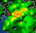
Short Range radar and visual imagery
courtesy of the National Weather Service
and radar.weather.gov.
NWS images are
downloaded and processed using StormPredator. Images are further processed
for file conversion and file size reduction and uploaded to this website every 15 minutes on
the quarter hour by Boulder-Creek.com. Refresh
the page if it appears that
imagery is missing or corrupted.
The red dot
near the center of the image is the location of Boulder-Creek.com
weather station. Also if there's a partial image file (lower or top half
of the image is missing - due to the webpage downloading the file while
a new file is being uploaded to the website), refresh the webpage. |
|
|
BTW: If you zoom up to the very center
during heavy coverage, you
will see the "cone of silence" of where the radar is unable to scan
directly over head due to its maximum tilt elevation of 19.5°. For more
information on NEXRAD Doppler Radar see NWS's
WSR-88B Radar FAQ. |
 |
|
| |
|
 |
|
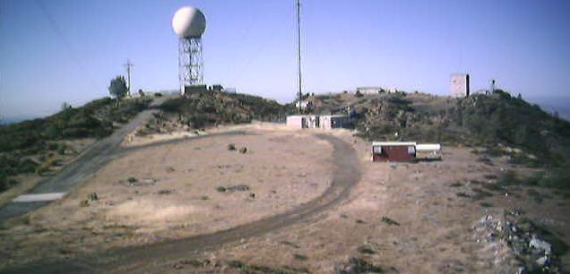 |
Radar imagery is from the top of Mt. Umunhum
which is the fourth highest peak in the Santa Cruz Mountains and is
located in Santa Clara County. NOAA maintains the NEXRAD Doppler
Radar site. Image from
Assault on Mount Umunhum an excellent story of bicycling up to
the top and everything about Mt. Umunhum. |
|
| |
|
 |
| Copyright © 2008 All rights
reserved. Boulder-Creek.com. |
| Revised:
16 May 2009 21:41 -0700 GMT
(Pacific) |
