| |
Cresta
Vista, Boulder Creek, California 95006 USA |
| Lat: 37.140° Lon: -122.127°
Alt: 695 feet |
| CWOP Site ID: C1844
Wunderground ID: KCABOULD3 |
| Real-time weather data
updated frequently. |
|
Current Station Operational Status
10-23-2020 Installed air particle counters from PurpleAir and added widgets to the main page.
11-11-2020 Added PurpleAir Air Quality Index map of Boulder Creek to main page.
11-12-2020 Updated Space Weather page.
01-22-2021 Power outage took out the server's power supply despite it being on a UPS. Some pages will not be updated until repair is completed.
01-28-2021 Power supply replaced in weather server and back online. Repairing some webpages that gone off.
12-16-2021 Replaced failed air particle sensor display in webpage with new display. |
03-09-2023 Rain bucket offline. Suspect snow messed up the tipping bucket.
03-11-2023 Rain bucket failed with crud buildup. Rain totals are invalid. Hoping to climb the roof and clear it out.
08-17-2023 Rain bucket has been throughly cleaned. Dirt had plugged up the drip hole. |
|
|
|
|
|
|
| Chrome update of 76.0.3809.132 introduced a bug, which stretches horizontally all menus that contain left/right background images in their items. Let me know if this is an issue. |
|
|
|
|
|
|
Local Weather
Warnings and Forecasts |
|
|
      No Warnings

CAZ512-040400-
Santa Cruz Mountains-
602 AM PDT Mon Aug 3 2026


.TODAY...Sunny. Highs in the 80s. South winds up to 5 mph in the
morning...becoming light.

.TONIGHT...Mostly clear. Lows in the mid 50s to lower 70s. Light
winds...becoming south up to 5 mph after midnight.

.TUESDAY...Sunny. Highs in the 80s. South winds up to 5 mph.

.TUESDAY NIGHT...Mostly clear. Lows in the mid 50s to upper 60s.
Light winds...becoming south up to 5 mph after midnight.

.WEDNESDAY...Partly cloudy in the morning then becoming sunny.
Highs in the 70s to mid 80s. Southwest winds up to 5 mph.

.WEDNESDAY NIGHT...Mostly clear. Lows in the 50s to mid 60s.

.THURSDAY THROUGH SATURDAY NIGHT...Mostly clear. Highs in the
upper 70s to lower 90s. Lows in the upper 50s to lower 70s.

.SUNDAY...Sunny. Highs in the lower 70s to mid 80s.


$$
|
|
|
|
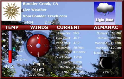
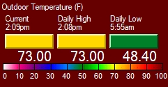
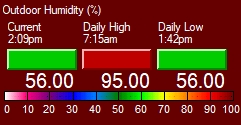
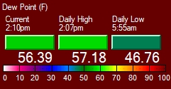
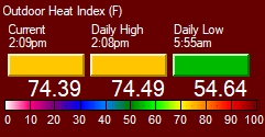
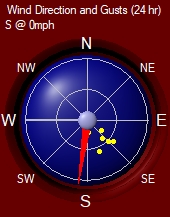
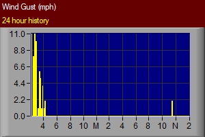
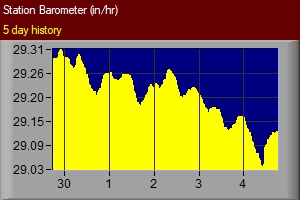
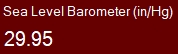
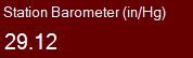
Current
Temperature, Humidity, Wind and Pressure |
|
|
|
|
|
|
|
|
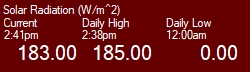
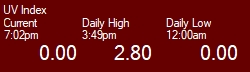
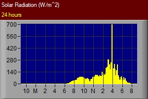
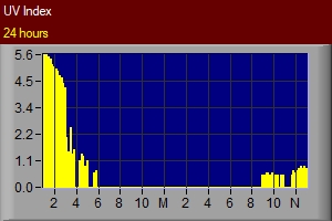
Current Solar Radiation and UV Index |
|
|
| |
* Mid-day drops is due to the sunlight passing through neighboring trees. |
|
Air Particle Counters |
|
Outdoors US EPA PM2.5 AQI |
Indoors US EPA PM2.5 AQI |
|
|
|
|
Loading PurpleAir Widget...
|
Loading PurpleAir Widget...
|
|
| |
| |
| Temperature Converter Utility - Convert between Fahrenheit and Celsius .... |
|
Mobile Weather Report for your PDA and Smartphone! |
|
Checkout This Hour's
Detailed Weather Observations and Calculations ....
|
|
| Visits to Boulder Creek
Weather |
|
|
| Copyright © 2020 All
rights reserved Boulder-Creek.com. |
| Unauthorized duplication
or distribution of pages and weather data is prohibited. Data requests are available. |
| Never base
important decisions on this or any weather information obtained from the
Internet! |
| |
|
| |
| Send comments to webmaster@boulder-creek.com |
| Revised:
26 Dec 2010 00:28 -0800
|
| Top |
| |
| |
| |